AKIPRESS.COM - 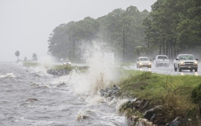 People from the Florida Panhandle down to the Tampa area braced Thursday for Hurricane Hermine, as it lashes the area with strong winds and potentially dangerous storm surge, Fox Newsreports.
The National Hurricane Center said the storm's winds ratched up from 75 mph in the afternoon to 80 mph by evening as the former tropical storm gained new fury.
Hermine was set to make landfall late Thursday or early Friday, forecasters said. A hurricane warning was in effect for Florida's Big Bend from the Suwannee River to Mexico Beach. And on the East Coast, a tropical storm warning was issued for an area that extended from Marineland, Florida, northward to the South Santee River in South Carolina.
Hermine marked part of a one-two punch of severe storms hitting the U.S. as Tropical Storm Madeline pummeled shorelines of Hawaii's Big Island. The storm was downgraded from hurricane strength on Wednesday but still packed winds reaching 50 mph on Thursday as it passed by the island.
If Hermine continues to maintain hurricane strength by the time it makes landfall, it would be the first hurricane to slam Florida since Wilma in 2005. Tens of thousands of people could be in Hermine's path as it moves northeast.
Forecasters warned Hermine could pack wind gusts topping 80mph with storm surge reaching 7 feet. The storm is likely to be felt the strongest across the Big Bend of Florida, which is relatively less populated than points west and inland.